OTE - Oregon Travel Experience

The Cascadia Earthquake and Tsunami of 1700

Posted on: September 19th, 2011 in Historical Marker Audio Tours, Historical Marker Details |

 
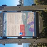
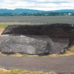
During the 18th century, Native American villages occupied the mouths of nearly every stream along this coastline – including here at Siletz Bay.
References to great flooding and ground shaking events are recorded in the oral traditions of many Pacific Northwest coastal tribes. These stories include instructions about how to prepare for large flooding events.
On January 26, 1700, the earth shook violently in the throes of a magnitude 9+ earthquake that …

Read More

Glacial Erratics

Posted on: September 19th, 2011 in Historical Marker Audio Tours, Historical Marker Details |

Subject:  This fine-grained rock was rafted to this location during catastrophic floods that occurred during the end of the Ice Age.
The 90-ton glacial erratic rock at the top of this 1/4 mile-long trail is a stranger from a distant location- it was transported here thousands of years ago on an iceberg in the wake of a cataclysmic flood.
During the last Ice Age, 13,000-15,500 years ago, a giant glacier dammed the …

Read More

Champoeg State Park

Posted on: September 19th, 2011 in Historical Marker Audio Tours, Historical Marker Details |

Subject: The site where Oregon’s provisional constitution was adopted in 1843.
This area, once named tchámpuick, the ‘place of yampah’ was the traditional homeland of the Tualatin Kalapuya tribe.   Fur trappers first arrived here by canoe in 1811, and they found lush open prairies bordering the Willamette River.  In 1830, French-Canadians retiring from the Hudson’s Bay Company and their Indian wives began farms and raised families near here.  Champoeg soon became a …

Read More

Cannons on the Beach

Posted on: September 19th, 2011 in Historical Marker Audio Tours, Historical Marker Details |

History in the Sand
Cannon Beach was named after a carronade (a short, smoothbore, cast iron naval cannon) found buried in the sand nearby. The cannon broke free of hte USS Shark’s deck during a shipwreck at the mouth of the Columbia River on September 10, 1846.
Recovering th First Cannon
Shortly after the wreck, a USS Shark crewmember learned from Tillamook Indians that part of the ship’s deck washed ashore south of …

Read More

Camp Adair

Posted on: September 19th, 2011 in Historical Marker Audio Tours, Historical Marker Details |

Subject: Site where military divisions were trained during World War ll
The US War Department ulimately selected 55,000 acres at this location for an infantry training site in 1941. Temporary quarters were constructed, and the site was dedicated as Camp Adair in 1942. Camp Adair was designed to train two divisions at the same time.
CAPTION #1:
The camp was named after Lt. Henry R. Adair, a West Point graduate and Oregon pioneer descendant, …

Read More

River Highway

Posted on: September 19th, 2011 in Historical Marker Audio Tours, Historical Marker Details |

Native peoples have resided along this river since time immemorial. The river and adjacent lands have provided a bountiful life and a highway for extensive trade and travel. In the 1700s, European and American seafarers began plying the Pacific coast, seeking commerce, mapping, and claiming places along the way. In October 1792, HMS Chatham entered this river. Lieutenant Broughton, ship captain, led the party in small boats upriver to this …

Read More

Boone’s Ferry

Posted on: September 19th, 2011 in Historical Marker Audio Tours, Historical Marker Details |

Subject: Tells the history of the Boones Ferry across the Willamette River near this site.
During the period of Oregon’s Provisional Government (1841-1849), residents traveled by Indian trails, water courses, or on primitive rough-hewn wagon roads etched by emigrant settlers. During the days of the Territorial Government (1849-1859), and long before the State Highway Commission was established in 1917, travel and commercial transportation was often the result of ambitious, enterprising Oregonians such …

Read More

Beacon Rock

Posted on: September 19th, 2011 in Historical Marker Audio Tours, Historical Marker Details |

Beacon Rock

Beacon Rock is a monolith, the core of a young volcano that erupted around 57,000 years ago. It is claimed to be the second largest free-standing monolith in the world. Lewis and Clark named it Beacon Rock in 1805. Native tribes and Lewis and Clark recognized that Beacon Rock marked the last of the rapids on the Columbia River and the beginning of tidal influence from the Pacific Ocean, …

Read More

Baker

Posted on: September 12th, 2011 in Historical Marker Audio Tours, Historical Marker Details |

Baker

Subject: Baker City is recognized for its place in the early transportation system for gold discovery.
In October 1861, a group of prospectors in search of the mythical Blue Bucket Mine, made camp on a creek six miles southwest of here. That evening, Henry Griffin discovered gold in the gulch which bears his name. That started a stampede which continued for years. In 1862, Baker County was created and named for …

Read More